Seated at the Fort Station, waiting for the Kelany Valley Train, my attention was drawn to an announcement over the PA system informing that the train to Thalaimannar is scheduled to leave in a few minutes. Ironically, the train of thought that stemmed from what I had just heard led me to the revelation that I’ve never been to that part of the Island. That night I brought up the topic with my wife and we put in to motion the plan to visit Mannar as our next excursion.
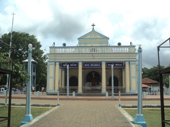
Madhu Church
Mannar is the main town of the Mannar District in the Northern Province of Sri lanka. From Colombo there are two routes by road to Mannar. The shortest route is via Puttalam-Silawaturai and Vankalai. The other route is through Anuradhapura-Madawachchiya. And of course there is a train service available for travelling to Thalaimannar. We headed to Mannar when we visited Anuradhapura. Thus, we took the A14 road via Madawachahiya towards Mannar armed with a checklist of “must visit” locations. The first stop was the Madhu Church.
About 40 km from Madawachchiya on the A14 road you will find the Madhu Road Junction. There is a turn off to the right that leads to the St. Mary’s Church at Madhu (Shrine of Our Lady of Madhu). The massive church complex is about 11 kilometers away from the main road. Throughout the year the Church is visited by devout Catholics, but is at its busiest during the Madhu Festival in July. Built in the nineteenth-century, this Portuguese style church is home to the statue of Our Lady of Madhu, which is believed to bring blessings upon all who visit the church. It is believed that the statue was brought to Madhu in 1670 by Catholics fleeing persecution by the Dutch.
Continuing on our way down the A14 from Madhu Road, near the 69th kilometer post we turned off to the left to the Nurukan – Silawathurai road. When we reached the T-junction at Silawathurai, we turned left to the Nurukan-Silawathurai road. About 2 km down this road is the “Doric of Aruppu”, at least what is left of it. The remains of the building are on a slight hill between the road and the sea. The area around the building is bare and the wind is very strong! Hang on to your hat and be careful when you open the car door, things inside may get blown away too! The two story building was built by Governor Freddrick North using bricks and mortar in the Greek Doric style of architecture, while the exterior was plastered with Chunam giving the building a marble like appearance. The area on which the structure has been erected is known as Arruppu, hence the name “Doric of Arruppu”. This magnificent building was used by the Governor to revive and supervise the Pearl Fisheries carried out in this area which was a major source of income for the Government. Being located on a low cliff near the beach, exposed to extreme weather and lack of maintenance has caused the building to deteriorate to its present condition.
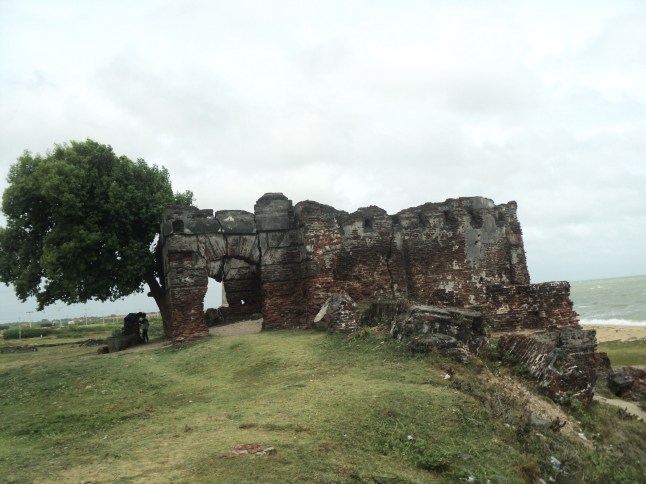
Doric of Aruppu
Further down the Nurukan-Silawathurai road, you reach the Jaffna Junction on the A14 highway. The main road continues over the Causeway to Mannar Island. The turn to the right takes you to Jaffna. From here you get a clear view of the Causeway which is about 3 km long connecting the mainland to the Mannar Island.
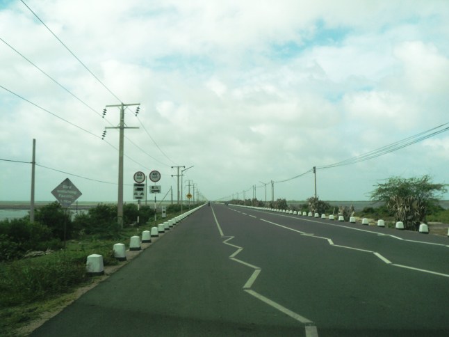
The Causeway connecting the mainland to the Mannar Island
Mannar Island is a dry and barren peninsula located in the Bay of Mannar. Though it’s referred to as an islet, it is in fact a peninsula formed in the shape of a tongue.
As you enter the Island you find yourself in the Mannar Town. The town is occupied by traders and most of the Government institutes are located in this part of the Island. There is also a small fishing port on the south-eastern shore of the islet. Apart from the recently established Garment factory there are no manufacturing establishments. However there are quite a number of hotels that cater to all categories of visitors.
The dry and windy climate is not suitable for cultivation; making fishing the main lively hood of the locals. Mannar is famous for Dry Fish. On one side of the market there is a row of Dry Fish stalls with a wide selection of Dry Fish. These items are fresh and quite cheap and Dry Fish connoisseurs will definitely love their taste.
The A14 highway passes through the town and heads towards the westernmost tip of the island. The highway as well as the railroad end there. This placed is called Thalaimannar. The Lighthouse on the beach is an important landmark and so is the Pier. The railroad and pier were built by the British to facilitate the transport of Indian laborers who were employed in the Tea Industry. There had been a ferry service between Dhanaskody in Southeast India and Thalaimannar. The Ferry had docked on one side of the pier and the train had stopped adjacent to the ferry on the pier to allow passengers to disembark from the ferry to board the train and vice versa. During the early days travel between India and Sri Lanka was mainly by Ferry and popular with pilgrims visiting Dambadiva. The ferry service was suspended with the advent of the civil unrest and today the Pier is in a dilapidated state and not accessible to the general public. There is a navy post next to the Pier and the Pier is used by the navy for their activities.
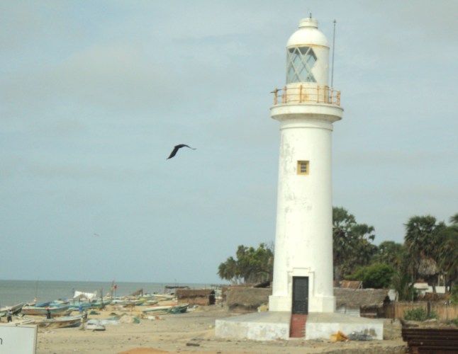
The Thalaimannar Lighthouse
The Thalaimannar Pier is about 37 km from the point you enter the Island. After passing the town the road runs through barren land devoid of any big trees except for Palm Trees which dominate the scenery. The rest of the vegetation comprise of shrubs with small leaves which are found in the dry zones.
Before you reach the Pier, there is a road to your right near the Police station in the town itself. This road is called Beach Road which leads to the Navy Camp around 2 kilometers away. The road ends here. The famous Adam’s Bridge is beyond this point and is unfortunately not open to the public due to security reasons. Satellite images published by NASA indicate that there had been a bridge that connected India to Sri Lanka which is known as Adam’s Bridge.
Archaeological studies have brought to light that the first signs of human inhabitants in Sri Lanka date back to the primitive age, around 1,750,000 years ago. The age of Adam’s bridge is almost equivalent. This bridge is related to the epic story of Rama and Seetha and it is believed that it was possible to walk across the bridge until a cyclone in 1480 damaged it.
The most striking feature about Mannar is the dryness of the area and the harsh sun that beats down relentlessly and the intermittent gusts of strong wind that sweep across the flat land. Rain is restricted to the rainy season during which time it rains really hard inundating the flat land. The rest of the year is mainly dry and ideal for drying fish.
An interesting and unique feature in Mannar is the presence of stray donkeys. They are seen roaming the roads and fields, feeding on the sparse vegetation like the cattle that are seen in the other parts of the island.
Speaking of vegetation, one cannot forget the Baobab trees. These trees, that are believed to have been brought from Africa, were planted by Arab Traders to feed Camels. According to data available there are about 40 such trees which are 300-400 years old. The oldest and largest Baobab Tree is at Pallimunei which is believed to be about 800 years old. This trunk of the tree has a circumference of 19.5 meters and the tree stands 7.5 meters tall. This iconic tree is worth seeing. To reach the site, turn right on to the Pallimunei Road when you enter the Island from the causeway and proceed about 500 meters. The historic tree stands majestically by the side of the road.
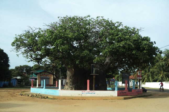
The oldest and largest Baobab Tree at Pallimunei
Another interesting landmark is the Old Dutch Fort which is a square-shaped fort with four bastions situated to the right of the causeway by the beach as you enter the island. The Fort was built by the Portuguese in 1560 and later rebuilt and occupied by the Dutch and British in 1696 and 1795 respectively. It can be reached by taking the first right turn after entering the Town and passing the Court complex.
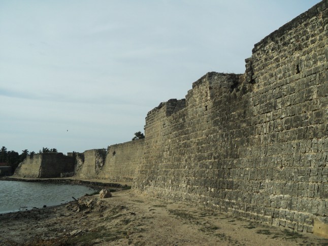
The Old Dutch Fort
The famous Thiruketheeswaram Kovil is another import place to visit. About 2 kilometers on the Jaffna road, there is a road to the left. The Kovil complex is situated about a kilometer down this road. The temple is venerated with great respect by Hindus. Everyone who enters the sacred temple should do so with bare feet and it is mandatory for all males to be bare-chested.
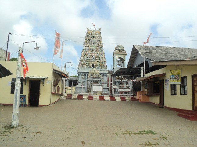
The famous Thiruketheeswaram Kovil
